We operate our roads using innovative and world-leading technology: artificial intelligence and machine learning; connected road infrastructure; dynamic lighting and more. Our roads also serve as testing grounds for future transport technologies such as autonomous vehicles.
We create city-sized solutions – building and operating safer, smarter and more sustainable roads – to solve pressing transport challenges.
See our current opportunities and learn what it’s like to work with us.
We trial and adopt leading-edge technology to deliver demonstrable benefits to our customers – setting new standards for safe, efficient and reliable road travel in the regions where we operate.
Our Australian roads are more than twice as safe as like roads, in part because of our investment in world-leading intelligent transport system (ITS) technology – everything from AI and machine learning capabilities to international-award-winning tunnel lighting.
This technology also delivers more efficient travel – saving customers both time and fuel emissions.
AI technology that’s helping keep drivers safe
The power of artificial intelligence (AI) is helping our customers get where they’re going. AI technology is used to help improve safety and efficiency across our Australian operations.
For example, in on CityLink in Melbourne, AI is helping with:
State-of-the-art traffic monitoring
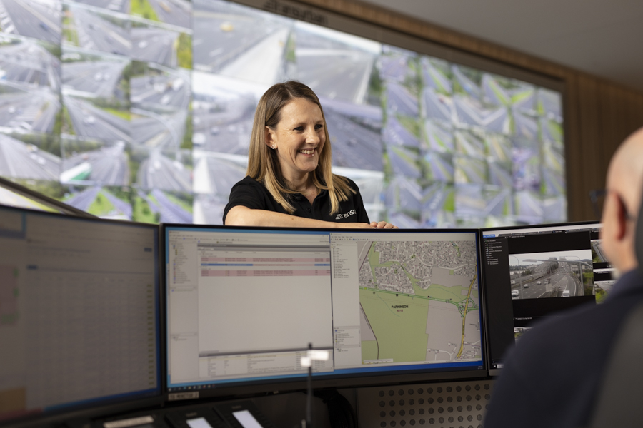
Across Sydney, Melbourne and Brisbane, our traffic control and incident response teams are supported by world-class technology such as automatic incident detection, smart sensors and artificial intelligence and machine-learning enabled systems.
This technology monitors roads for incidents such as debris and stopped vehicles and alerts operators for potential action. Shown here is our Transurban Queensland Network Operations Centre.
World-leading tunnel lighting design: NorthConnex
Lighting inside NorthConnex (Sydney) features forests, starry skies and speed lines. It looks pretty, but it’s about more than aesthetics. A world-first in tunnel design, the lighting is also helping keep drivers alert and engaged as they travel through the 9-kilometre tunnel.
The lighting’s advanced LED installations are designed to help motorists safely transition from bright daylight to the darker interior tunnel section, and to help people orientate themselves as they travel through the relatively long tunnel.
The lighting design received an International Association of Lighting Designers Award of Excellence in 2021.
TTransurban partnered with Transport for NSW, Austroads and the University of NSW on this project. The final design was many years in the making and involved driving simulators and a worldwide survey of tunnel users to understand driver behaviour.
Drone asset inspections
We’ve been using drones to conduct detailed inspections and maintenance of hard-to-reach areas, such as the under-sides of bridges. This makes a sometimes tricky job safer and easier for everyone.
Connected vehicle data
We use anonymised telematics data from Compass IoT to monitor our roads for safety issues and track the performance of safety interventions. This technology will be a major tool in the future of road safety – using accurate and real-time data to proactively identify trends and patterns before a crash happens. This technology will be a major tool in the future of road safety as we work towards zero fatal or serious injury crashes occurring on our roads.
Examples where connected vehicle data has helped us make roads safer for our customers and road workers include:
On CityLink (Melbourne) connected vehicle data (and CCTV footage analysis) showed an issue with last-minute merging near the final CityLink exit before the Domain Tunnel – patterns of hard braking and swerving indicated motorists were changing lanes too late. To address this, we installed early-warning signage and lane markers to help drivers navigate the exit.
Despite higher traffic volumes (Melbourne was emerging from lockdown at the time), we subsequently saw a 75% reduction in rear-end crashes and a 66% reduction in lane side swipes.
On the Gateway Motorway (Brisbane), near the off-ramp leading to the Port of Brisbane, we detected a cluster of sideswipe and merging incidents between motorists and heavy vehicles. Connected vehicle data showed vehicles hard braking and swerving where heavy vehicles were transiting to the port off-ramp.
In response, we trialled new signage, warning of both truck movements and exit locations, over a three-month period. The trial found a significant reduction in harsh manoeuvres, with the most severe incidents eliminated. As a result, we installed permanent signage. Without connected vehicle data, we would not have been able to reliably trial the temporary signage so quickly.
During construction of the M7-M12 Integration Project (Sydney) we are using connected vehicle data to enhance road-worker safety along the Westlink M7 motorway. We created a Tableau traffic-speed monitoring platform that is enabling implementation of measures to improve compliance with road-work speed limits (and better protect vulnerable personnel working alongside live traffic).
Dynamic pricing on the Express Lanes
Our dynamically tolled Express Lanes operate on three roads in the Greater Washington Area in the United States: the 95; the 395; and the 495. These tolled lanes run alongside the roads’ general-purpose (untolled) lanes. Barriers separate express from general-purpose lanes, and the express lanes have their own, dedicated entries and exits.
Toll pricing on the Express Lanes changes in real time, driven by a proprietary dynamic tolling algorithm. The dynamic pricing reflects demand: the more vehicles using the lanes, the higher the tolls. Pricing also serves as a lever to maintain minimum traffic speeds. Pricing signs are updated every 10 minutes so motorists can make informed choices about their choices. Vehicles with three or more occupants, motorcycles and buses all travel free.
The Express Lanes are supported by dedicated incident response services and 24-7 traffic monitoring.
Our roads are among the most technologically sophisticated in the world, fitted with cameras, sensors and dynamic signage and lighting, operated from state-of-the-art control rooms with AI capabilities.
The technology we invest in helps make our roads safer and more reliable for the 10 million customers who drive on them every year. It’s also paving the way for the introduction of new driving technology, including autonomous vehicles – our roads have become testing grounds for autonomous travel both in Australia and the United States. Read about our Smart roads trial.
Supporting state-of-the-art road safety research
The Transurban Road Safety Centre is Australia’s first research-dedicated crash test lab. The facility, operated by Neuroscience Research Australia (NeuRA), is equipped with a crash sled capable of reaching speeds up to 64 km/h.
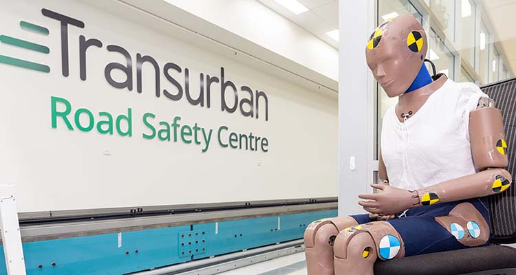
NeuRA’s world-class research, combined with its state-of-the-art facilities and equipment, contributes to innovative road safety solutions, focusing on targeted scenarios and occupant types. The centre’s research, shared with government, motoring bodies and other agencies, informs the development of more inclusive and effective road safety guidelines and regulations.
The centre’s research has included:
- how using comfort accessories (for example, seat cushions) affects crash outcomes
- how the position of a motorcycle's fuel-tank positioning can affect pelvic injuries
- how rear-seat passengers are injured in crashes
- how incorrect child-car-seat use affects performance, including when seats are modified to accommodate children with disabilities.
Trialing future transport technology
Connected roads, transport solutions and autonomous vehicles have the potential to deliver smarter, safer ways for people and freight to get around. And we’re testing this potential – in real life, on our roads and on the wider road network.
Our connected and autonomous vehicle (CAV) trials help us and our trial partners prepare for a future where vehicles, roads and transport solutions communicate with each other, sharing data that helps make travel safer, quicker and more efficient for everyone on the road.
![]()